
Introduction
Sky-AR is the add-on solution for any pilot wanting to use the full capabilities of an Augmented Reality environment. Sky-AR keeps all flight and navigational data available at all times, no matter where the pilot is looking.
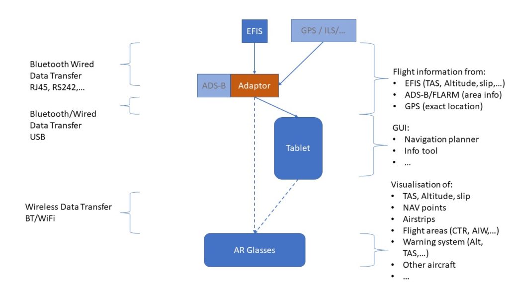
Sky-AR consists of an EFIS interface, a tablet running the Sky-AR navigation software and a pair of Augmented Reality glasses .
Sky-AR can easily be integrated in any aircraft equipped with and EFIS, without major cabling or cockpit modifications.
Founding principles
Augmented Reality
The pilot sees the world through Augmented Reality glasses adding flight and navigation data (waypoints, CTR, TMA,..) as well as possible dangers to his clear view of the skies.
Nearby airfields are indicated by the Augmented Reality glasses and the airfield’s information is made available on the tablet.
If the airfield has an ILS available the ILS data will be used to create a « funnel » to assist the landing procedure. If there is no ILS system available a theoretical « funnel » can be used to assist the landing procedure.
The EFIs interface is equipped with an A-DSB receiver allowing Sky-AR to display A-DSB equipped aircraft within a specified airspace around the Sky-AR equipped aircraft.
All the elements that can be found on aerial maps (e.g. windmills, powerlines, CTR, TMA,…) will become visible in the Augmented Reality environment of the pilot whenever the aircraft comes within a safety distance of these elements.
Augmented Navigation
The tablet’s Navigation App is used to prepare the flight and all-important flight elements are visible through the Augmented Reality glasses.
The navigation waypoints are visualized in space at the (flight planning) defined coordinates and heights. The different types of airspace (CTR,AWY,TMA,…) are visible as three-dimensional object when the aircraft comes within a minimum safety distance of them.
Augmented Safety
The pilot can stay focused on what is happening outside of the aircraft without risking “Tunnel Visions” and losing sight of important flight parameters. The Sky-AR will highlight any flight parameters approaching safety limits to increase the pilot’s awareness and allow for corrective actions to be taken on time.
By comparing the aircraft’s airspeeds, it’s heading, and the actual ground path of the aircraft Sky-AR will determine and visualize the current windspeed and heading, saving time and focus during an eventual emergency landing.